A Road Trip in Ladakh (19th August to 28th August, 2023)
I had been planning a road trip in Ladakh for a few years. It got thwarted a couple of times due to unforeseen circumstances. Finally, I was able to do a trip this year from 19th August to 27th August.
The preparation for the trip was
over 3 months. Creating and refining an itinerary several times. The idea was
to go to a variety of places without stretching ourselves too much physically.
We had that altitude sickness is an issue. We also knew that in some areas the
roads are bad and connectivity is non-existent. So, we wanted to keep a reserve
day towards the end. As it turned out, we almost needed that extra day.
Finally, we took off from
Delhi on 19th August. Kushok Bakula Rimpochee Airport is one of the highest
commercial airports in the world situated at 3,256 meters above sea level.
The approach to the airport is spectacular from the aircraft.
From
the flight path, one sees an array of mountains and some of them have snow peaks.
The mountains are rugged here with very little vegetation. This is a rain
shadow region and there is very little rain over here.
Someone
has taken a video from the aircraft and put it out. That's here...
I
took a few photographs, but no video. As the descent starts it becomes
interesting as the aircraft sinks below some of the mountain tops. These
mountains are barely 150-200 meters away (my estimate).
Coming
from Delhi, the first thing one notices are the clear blue skies.
There
wasn’t much to do on the first day. As advised, we acclimatised for the first
day at our resort in Shey. We would stay in Shey for the first two and the last
two days of the trip. Our vehicle for the travel was a Toyota Innova.

Our
trip was to be over 1200 km through various terrain, some good, some bad, some
indifferent.

Day
2
A
museum built by the Indian Army called the Hall of Fame is situated close to
the airport.
The
ground floor of the Hall of Fame has pictures of the Kargil War on the walls.
This tells stories of how the Indian Army fought during the war. There is a
separate wall named “Lest We Forget” which showcases the images of the soldiers
who laid down their lives to protect their nation.
On
the same floor, there is a projection room where you can watch a documentary on
“Operation Vijay”.
The
museum has a section that exhibits the culture, history, and facts about
Ladakh.
On
the upper floor, there is an area called OP Vijay Gallery, where you can
witness several weapons used in the Kargil War. There are also arms and
ammunition taken by the Indian Army during the war of 1999.
The
same floor has another area displaying apparel and amenities that the Indian
Army used in the Siachen region. Pictures here also display the army posts on
this glacier, their accommodation, and their training process on ice walls.


More photos here
Our next stop was The Magnetic Hill. This is on way to the confluence of Indus and Zanskar.
At
a distance of around 30 km from Leh, there is a Magnetic Hill marked by a
yellow signboard which reads “The Phenomenon That Defies Gravity”.
It
instructs you to park your vehicles in the box marked with a white point on the
road, which is known as the Magnetic Road. When parked at the indicated spot,
vehicles begin moving in one direction, apparently defying gravity.
There
are two theories explaining the reason behind this uphill movement. The most
common one is that the hill has a strong magnetic force which is why it pulls
vehicles in the vicinity. In fact, so strong is this magnetic force that planes
of the Indian Air Force avoid this route so that they don’t face magnetic
interference on their devices. (I find it hard to believe this theory)
Another
popular theory is that of an optical illusion. According to this, the hill does
not really have a magnetic force but it just creates an optical illusion of
sorts so that the road, which actually goes downhill, seems as if it goes
uphill. Therefore, when you see the vehicle going upslope, it is actually the
opposite and does not defy the laws of nature. This appears believable to me
Apart
from this there's a lot happening around here. Off-road rides and the like.
Very picturesque around here, but that seems to be true everywhere.

More Photos here
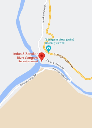
In
the map, we see the Indus flowing from the east towards north and the Zanskar
join in from the south west. However, we see the Sangam from the other side and
therefore the river Indus is flowing from left to right and the Zanskar joins
in from the top side.
The
Indus River begins its journey near the Mansarovar Lake, in Tibet in China - a
glacier near Bokhar Chu (31°15’ N latitude and 81°40’ E longitude) in the
Tibetan region at an altitude of 4,164 m in the Kailash Mountain range.
Very
import, because India, Hindu, Sindhu, Hindi all derive their name from this
river which irrigates the bulk of Pakistan.
The
Indus River has a length of around 2880 km, of which only about 700 km are in
present day India; the remaining distance is divided between Pakistan and
Tibet.
The
Sangam here is very different from those in Garhwal Panchprayags. There is no
real religious significance attached to it here and there aren't any temples
here.
There's
river rafting as in some of the Panchprayags.
This
road, along side the Indus is the Leh-Kargill-Srinagar Highway. It follows the
Indus for most part.

More pictures here
The
next stop. It's called Gurudwara Pathar Sahib. I wonder why? It is surrounded
by rocks on all sides though.
The
Gurdwara was built in 1517 to commemorate the visit to the Ladakh region of
Guru Nanak Dev, the founder Guru of the Sikh faith. During his lifetime Guru
Nanak travelled to many distant places and one such place was Tibet. Guru Nanak
is well respected by Tibetan Buddhists who consider him a saint; The Dalai
Lama, spiritual leader of Buddhists in Tibet, has confirmed this in his discussions
with some Sikh leaders saying that Tibetans revere Guru Nanak as a Buddhist
saint under the name of Guru Gompka Maharaj.
It
is maintained by the army these days.

More pictures here
Our
next stop - Shanti Stupa is a Buddhist white-domed Stupa on a hilltop in
Chanspa, Leh district.
It was
built in 1991 by Japanese Buddhist Bhikshu, Gyomyo Nakamura. The Shanti Stupa
holds the relics of the Buddha at its base, enshrined by the 14th Dalai Lama.
The Stupa has become a tourist attraction not only due to its religious
significance but also due to its location which provides panoramic views of the
surrounding landscape.

More
pictures here https://m.facebook.com/story.php?story_fbid=pfbid0YtFLm4HTBPZ4dmHPy3PUUE7aJAeday2A7ywCUP1mw16Hmpe9hUJDRbWu8t1s96Dql&id=1172996176&mibextid=Nif5oz
Our
last stop for the day. It was advised to keep the day light, to adjust to the
altitude.
Leh
Palace also known as Lachen Palkar Palace is a former royal palace overlooking
the city of Leh in Ladakh. It was constructed circa 1600 by Sengge Namgyal. The
palace was abandoned when Dogra forces took control of Ladakh in the mid-19th
century and forced the royal family to move to Stok Palace.
.Much
of the palace is in deteriorated condition, and little survives of its interior
decorations
The
Palace Museum holds a rich collection of jewellery, ornaments, ceremonial
dresses and crowns. Tibetan thangka or paintings, which are more than 450 years
old, with intricate designs still retain the bright colours derived from
crushed and powdered gems and stones.

More
Pictures here https://m.facebook.com/story.php?story_fbid=pfbid0DivfLi6r6DUPcY633eeVGX9Xy7tUYY6YVcsJ7jQBtcVuU5qptHgS9nvp9v76Ko2jl&id=1172996176&mibextid=Nif5oz
It was
only our 2nd day here and we have only been in the vicinity of Leh. Already the
rugged landscape has made a huge impression. It's barren and rock and therefore
there's a lot of dust around but it gives a very different look, which changes
continually through the day.
Here's
some samples. But photographs can't really do justice to the splendor that I am
witnessing.

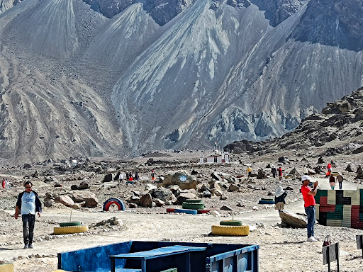
On the third day, we were off to Nubra Valley via Khardung La pass.
Khardung
La Pass is at 18,300 feet (5,770 meters). It's higher than any place in Europe
or North America. There aren't many motorable roads at this altitude anywhere.
However,
these are just local signages. In reality, it is 5,359 m (17,582 ft). Doesn't
change much.
The
pass is on the Ladakh Range, north of Leh, and connects the Indus river valley
and the Shyok river valley. It also forms the gateway to the Nubra valley,
beyond which lies the Siachen Glacier.
It's
high enough to suddenly see the surrounding mountains as your equal. Only half
an hour ago, they were towering over us. And half an hour later, they were
again towering over us as we descended into the Nubra valley.
We are
also at the permanent snow line, where we can see some snow
I
really don't have an expert eye on these matters, but the gradient on these
roads didn't appear to be steeper than normal. If anything it was a bit gentler
than some of the slopes in HP. However, it must have been a very difficult road
to build. Supply lines are far away, the altitude is debilitating, and the
enemy lines are close by. It gets really cold here after summer.
A
motorable road through the pass was built in 1976, and opened to public motor
vehicles in 1988. Maintained by the Border Roads Organisation.

More pictures here https://m.facebook.com/story.php?story_fbid=pfbid0VMG5EeeUdciAYjY2JN9Gbn2RsujC2JtQhKeyCcKHnVqFrXEB6QGQH8b7cYmgGME5l&id=1172996176&mibextid=Nif5oz
The Shayok river is a big river to the north of indus that flows westwards almost parallel to the path of the Indus.
This
river is the main river in the Nubra Valley and we will follow it all the way
to the LOC with Pakistan.
Around
Khalsar it's really wide with a lot of white sand around. This large area is
used for adventure sports - zip lines, ATV rides, etc. There are even
go-karting tracks around.
The
river goes further to Hunder where we see sand dunes. There are twin humped
camels here, available for rides apart from other adventure sports and camping.
These
two humphed camels are of central Asian origin, quite distinct from the ones
seen in Rajasthan.

More pictures here
Diskit Monastery also known as Deskit Gompa or Diskit Gompa.
It
belongs to the Gelugpa (Yellow Hat) sect of Tibetan Buddhism and was founded by
Changzem Tserab Zangpo, a disciple of Tsong Khapa, founder of Gelugpa, in the
14th century.
The
monastery has a statue of Cho Rinpoche (Crowned Buddha) in the prayer hall, a
huge drum and several images of fierce guardian deities. An elevated cupola of
the monastery depicts a fresco of the Tashilhunpo Monastery of Tibet.
The
monastery administration runs a school, with support from a non-government
organization known as the "Tibet Support Group". The school has
computer facilities and teaches science subjects, in English, to Tibetan
children of the region.
There
is a very large statue of Jampa (Maitreya) Buddha. This impressive 32 metre
(106 foot) statue on top of a hill below the monastery, faces down the Shyok
River towards Pakistan and, according to Tsering Norphel, chairman of the
committee that commissioned it, most of its funding came from local donations.
The head of the Gelugpa, Ganden Thipa (the reincarnation of Tsongkhapa), and
abbott of the Rizu monastery, gave 8 kg of gold for its decoration. It is the
first time a Ladakhi monk has been the head of the Gelugpa sect.
The
statue's construction was begun in April 2006 and it was consecrated by the
Dalai Lama on 25 July 2010. Nophel says the statue was built with three main
functions in mind - protection of Diskit village, prevention of further war
with Pakistan, and world peace.

More pictures here https://m.facebook.com/story.php?story_fbid=pfbid033q8uC6QLT6TaaGjqHxBvCWxU6C58TzBrf5ErorZypEuQCY2tXywzdeSXWAYj5mhDl&id=1172996176&mibextid=Nif5oz
We stayed overnight in Diskit and we will be staying here tonight. We discovered that the whole of Nubra valley is yet to be connected to the national grid (Leh got connected about 5 years ago). Here, every place has a centralized DG set. The one in Diskit provides electricity from 5 pm to 11 pm and then from 6 am to 8 am.
Travellers
need to be aware so that the phones are charged in time. Also the ATM won't
work outside these hours. The power available is obviously expensive, but the
government might be subsidising it. Additionally, people keep smaller gensets
at home/ hotels, for emergency.
Today
we travelled along the Shyok to three places - THOISE, Turtuk and Thong. The
last one is a border village beyond which lies Pakistan occupied Kashmir.
Thoise
Airbase is a military airfield and small village in Nubra. It's about 20 km
from Hunder along the Shyok river. The airstrip is a critical facility enabling
a quick inflow of men and material from the Indian interior to Siachen, a
glacier, helipad and battleground near the Actual Ground Position Line between
India and Pakistan.
It
appears to be a hot summer this year and the glacier has melted faster than
usual. Shyok is full and the currents are strong. We cross the river about 20
km after the airbase, and then cross back to this size after another 20 km,
before entering Turtuk. We then cross it once more before arriving at the
border village. These bridges are very basic and only one vehicle at a time is
allowed.
The
Turtuk back story
Turtuk
was part of Pakistan occupied Kashmir until December 1971, when the Indian army
occupied the village (and 4 other villages with it) during a border war along
the Line of Control and never gave it back.
There
is only one way in to Turtuk which is surrounded by Karakoram range on one side
and the Ladakh range on the other. It is hemmed in by Rocky walls on every
side.
While
the rest of Ladakh is Buddhist, inhabited by Ladakhi Tibetans, Turtuk is a
Balti village (Baltis are an ethnic group of Tibetan descent who mostly live in
Pakistan's Skardu region). Villagers are Noorbakshia Muslims, a Sufi sect of
Islam, who speak Balti (a Tibetan language), wear shalwar kameez and have far
more in common with the people of Baltistan.
The
villages become important as they provide one of key passages to Siachen.
Looking
at the natural fortification, it's a bit of a surprise that Pakistan failed to
defend it. Maybe, back in the day they did not consider Siachen important.
In
2010 Turtuk was opened up to tourism, allowing outsiders to see a unique
village and way of life. The Balti residents make the most of the high
Karakoram rock walls that surround them, building elaborate stone homes over
cobblestone alleys as well as rock irrigation channels to water their crops.
Turtuk
is lower than other places in high-altitude Ladakh, set at a mere 2,900m. At
this elevation, summers can be extremely hot (I can vouch for the heat) and the
villagers have made use of their rock surroundings to build natural
stone-cooling storage systems, used for storing meat, butter and other
perishables during the warm months. Known as 'nangchung' in Balti, which means
'cold house', these stone bunkers are designed to have gaps that allow cold air
flow to pass through, keeping the goods cooler than the outside air
temperature.
The
Battle of Turtuk was a military engagement between India and Pakistan that took
place during the Indo-Pakistani War of 1971. Fighting between the two sides
took place in Turtuk and its surrounding areas, then part of the
Pakistani-administered Northern Areas in Kashmir. Following this battle, Indian
forces captured Turtuk from Pakistan, which had controlled the area since the
Indo-Pakistani War of 1947–1948. Per the Simla Agreement, Turtuk was
incorporated into the erstwhile Indian-administered state of Jammu and Kashmir,
and formally became a part of Ladakh following the revocation of Article 370 by
the Government of India in August 2019.
There
isn't much to do in Turtuk apart from trekking and visiting the 2 monasteries
and the Royal House. The picturesque village with its tiny houses and fields is
surreal. It remains cut off from Ladakh for 6 months during winter.
There
are a couple of monasteries and it is claimed that K2 peak is visible from one
of them.
There's
a waterfall trek which people recommend. The restaurants are nice with variety,
people are nice and friendly, homestays are easily available.

More
pictures here https://m.facebook.com/story.php?story_fbid=pfbid0ssrRin8igahVbfndmSnAzSuC8rWAJztTZAUBj3JWSEe7NYQqi1VKoZsK2zaLZ4yHl&id=1172996176&mibextid=Nif5oz
A memorial has been built for the 20 Indian soldiers who lost their lives in action against the Chinese Army in the Galwan Valley after evicting them from an observation post near the Y-junction area there under Operation Snow Leopard.
As per
the operational details put out on the memorial wall, "On June 15, 2020 at
Galwan Valley, Col B Santosh Babu Commanding Officer, 16 Bihar led the Quick
Reaction Force of 16 Bihar and attached troops tasked to evict the PLA OP from
Gen AY Nala and move further to Patrolling Point 14."
This
is in a place called Chasthang, about 35 km further from THOISE as one moves
towards Turtuk alongside the Shyok
More pictures here https://m.facebook.com/story.php?story_fbid=pfbid02xQin6cXBg7Jv5hZfZx4b81ZsDxHNYH1VH2ixd22YH7dQWG7PncNFcnQYfaY5iQhPl&id=1172996176&mibextid=Nif5oz
In the
Nubra Valley, The majority are Buddhists. In the western or lowest altitude end
of Nubra near the Line of Control i.e. the Indo-Pak border, along the Shyok
River, the inhabitants of Turtuk are Balti of Gilgit-Baltistan, who speak
Balti, and are Shia and Sufia Nurbakhshia Muslims. Siachen Glacier lies to the
north of the valley.
This
is a small collection of village folks....

More pictures here https://m.facebook.com/story.php?story_fbid=pfbid0X7V29kv8d3eRUq1dahVbzqQWpvryHKQSeQmJVzfGmPYUXvxfCH8xyyCn4ZpqLdSNl&id=1172996176&mibextid=Nif5oz
The return from Diskit wasn't going to be via KhardungLa. We were off to Pangong Tso. We followed The Shyok up to Shyok village instead of turning south.
The
river was in full spate and had breached its embankment at 2/3 places. The cars
and bikes had to find their way through 10-12" deep water for distances
varying from 15 to 30 meters. This stretch of road was generally very bad,
filled with loose gravel, stones and dust. Real dangers to the tyres and axles.
And we did experience a tyre puncture.
After
Shyok village we finally left the river and headed southwards.
After
a while the roads again became good as we approached an army base. This was
Durbuk and the water was blue again unlike the muddy brown Shyok. Clearly this
stream hadn't travelled a long distance from its origin. It is however destined
to merge into the muddy waters of Shyok.
The
good roads continue till village Tangtuk which boasts of the highest IOC retail
outlet at 12933 feet. I suppose everyone traveling beyond, towards Pangong Tso
makes sure that their tanks are full and they are carrying extra cans of fuel.
I
wonder how the bikers handle this. They are everywhere and keep opening new
frontiers. Won't be surprised if there are small retailers storing and selling
fuel in all these little frontier villages where bikers like to stay.
After
this, the roads become bad again for a long stretch and then miraculously about
50 km from the lake an absolute gem of a road appears. This would continue all
the way to the lake, the long 20 odd km ride alongside it and another 20-30 km
beyond.

More pictures here https://m.facebook.com/story.php?story_fbid=pfbid026ejKkZVtBoiit71jF9A2su5gXhLPPVS2187wRfQj49T4zYjaj56jmQdNH2vFxP5Fl&id=1172996176&mibextid=Nif5oz
As mentioned, the road gets miraculously good about 50 km from the lake. This would continue all the way to the lake, the long 20 odd km ride alongside it and another 20-30 km beyond.
The
lake was much bigger than I expected. And on the next day I was surprised again
as I took the long ride along side it before breaking away.
After
another 15-20 kms the roads became bad again.
When I
checked later I found that the surface area of the lake is 700 sq km (to give a
perspective, Delhi state is twice that and Goa about 5 times that).
India
claims 1/3 of it (I am not aware of how much we actually hold. It's a state
secret.)
The
place lives up to all the pictures that one has seen before coming here. We
reached at around 2 pm and left at around 9 am on the next day.
Mostly,
there's only sand and gravel around it, except at the very end where there is a
meadow like formation and we saw some Yaks.
By
the, there is no network here and electricity from 7 pm to 11 pm

More pictures here https://m.facebook.com/story.php?story_fbid=pfbid02NnmcLPh7QM4eBJ6FfPcmc35Phs5NnAX2wFbZU9WpyyKLstfY7BFBZiX38FnBmdj8l&id=1172996176&mibextid=Nif5oz
We left Pangong Tso after breakfast.
Rezang
La, is a mountain pass on the Line of Actual Control between
Indian-administered Ladakh and the Chinese-administered Spanggur Lake basin
that is also claimed by India. The pass is located on the eastern watershed
ridge of the Chushul Valley that China claims as its boundary. It is at the
head of the Rezang Lungpa valley
In the
map, the doodled portion is roughly what China controls on the Pangong Tso.
Rezang
La War Memorial at Chushul was our next stop. It goes around a lot of hostile
territory and the total distance is of the order of 200 km. Once you leave the
lake area the roads become bad. Probably difficult to build. They would be
sitting ducks
The
inscription on the War Memorial at Chushul, Ladakh raised by the Indian Army in
memory of the soldiers who died in the Battle of Rezang La, reads as below...
"How
can a man die better, Than facing fearful odds, For the ashes of his fathers, And
the temples of his gods.
To the
sacred memory of the heroes of Rezang-La 114 martyrs of 13 Kumaon who fought
to the
last man last round against hordes of Chinese on 18 November 1962.
Built
by all ranks 13th Battalion the Kumaon Regiment."
The
memorial was built in 1963. It was a sombre looking modest place then. It's
been given a face lift recently with galleries and an AV display with a voice
over of Amitabh Bachchan.
The
120-strong company, led by Major Shaitan Singh, fought off over 1000 Chinese
soldiers at an altitude of over 18,000 feet until they ran out of bullets. In
fact, even after running out of ammunition, it is reported that the resilient
Indian soldiers utilised their bayonets and engaged in hand-to-hand combat with
the Chinese.
According
to the accounts, only 5 came back alive and a thousand Chinese died.
The
Chinese were even better clothed to survive the –24 degrees Celsius weather.
Before the day ended, 114 men of the Charlie company died. Five were taken
prisoners of war from where they all eventually escaped, and one was sent back
by the Chinese to narrate the account of events.
When
it comes to Chinese casualties, their official record says 500 and that is a
matter of debate. Kuldeep Yadav, the author of the book The Battle of Rezang
La, argues that over 1000 Chinese soldiers died.
In his
book, Yadav says that it was February 10, 1963, when the frozen bodies of the
gun-wielding men with bullet wounds on their chests were found. The fatal wound
spots seem to suggest that no Indian soldier attempted to flee from the Chinese
offensive.
Retired
Captain Amarinder Singh, in his book Lest we forget, said that the Chinese do
not usually pay tribute to their enemies killed in action. However, Rezang La
was an exception. According to his account, the Chinese had covered the bodies
of the Indian soldiers with blankets and even placed bayonets over them so that
the make-shift covers do not fly off. Such a mark of respect from the enemy
party is the highest acknowledgement of exceptional valour.
For
his courage and perseverance against near-impossible odds, Major Shaitan Singh
was posthumously honoured with India’s highest wartime gallantry award, the
Param Vir Chakra. Additionally, Kumaon Regiment's 13th Battalion was presented
the Theatre Honour ‘Ladakh 1962’.

More pictures here https://m.facebook.com/story.php?story_fbid=pfbid024bUNJ1gtZjFyKiWZeScL1P8nAVQbSuz5uanyXCYUSChEnruRDGvGAy32HZFoJRV7l&id=1172996176&mibextid=Nif5oz
We were now off to Hanle.
The
highlight - The Indian Astronomical Observatory (IAO) is a high-altitude
astronomy station located in Hanle, India and operated by the Indian Institute
of Astrophysics. Situated in the Western Himalayas at an elevation of 4,500
meters (14,764 ft), the IAO is one of the world's highest located sites for
optical, infrared and gamma-ray telescopes. It is currently the tenth (see List
of highest astronomical observatories) highest optical telescope in the world.
It is India's first dark-sky preserve.
The
first light was seen by the Observatory 2-metre telescope on the midnight hour
between 26 September and 27 September 2000.
The
satellite link between the Centre for Research and Education in Science and
Technology (CREST), Bangalore and Hanle was inaugurated by the then Jammu and
Kashmir Chief Minister Dr. Farooq Abdullah on 2 June 2001. The Observatory was
dedicated to the nation on 29 August 2001
In
September 2022, it became India's first dark-sky preserve. The Hanle site is
deemed to be excellent for visible, infrared and submillimeter observations
throughout the year.
A
dark-sky preserve (DSP) is an area, usually surrounding a park or observatory,
that restricts artificial light pollution. The purpose of the dark-sky movement
is generally to promote astronomy.
Hanle
is 109 km southwards from the war memorial at Chusul. Shortly we came across
the mighty Indus ( not so mighty here), about 200 km upstream from Leh.
We
went along with big brother till a place called Loma, where we turned left for
Hanle. We would come back and join it the next day and move towards Tso Moriri.
A
peculiar thing outside the village of Hanle is a cafe run by the military for
the public. Amazing. And so an omelette cost 40 bucks, coffee for 20 bucks,
aloo Paratha for 70.
Hanle
has about 70 homes and almost 60-65% of them are homestays. There are several
interesting treks around and village is extremely friendly (most ladakhis are).
By a
coincidence our host turned out to be an employee of the observetory and he
arranged for a person who has been provided with a small telescope to
popularise astronomy among children. He helped us see the Saturn and the star
vega and the milky way. Great experience
At the
observatory of course, you are not allowed to touch anything. There's stuff on
the net about the equipment being used there.

More pictures here https://m.facebook.com/story.php?story_fbid=pfbid02DUQ4DbGFq4N1KdpVxphXVFWPdDmQZNBfhy9EwRHwgu7GpTXcPWidizSLSU7brJ2Kl&id=1172996176&mibextid=Nif5oz
Tso Moriri. Tso means lake and Moriri means mountains. A lake surrounded by mountains.
The
lake is at an altitude of 4,522 m (14,836 ft). It is the largest of the high
altitude lakes entirely within India and entirely within Ladakh.
It
looks so much like Pangong Tso that one can easily get confused by photographs.
Comparison..
PT -
14272 ft or 4350 m altitude. Significantly lower than TM.
Area
-PT 700 sq km, TM 120 sq km. Much smaller, even though India's claim is only on
1/3
PT
excellent roads surrounding it. TM - terrible roads leading to it.
Further,
PT is fully military controlled, and cottages are allowed in specific
designated areas. The villages are a bit away from the lake.TM is all private
land with haphazard lively creations. If 3 things happen for TM (connected to
grid electricity supply, approach roads are built and traffic picks up) it can
really become a happening place. PT will always be a frontier with limits on
several things
Both
very very picturesque with lots of physical activities around them.
To get
to TM we left Hanle, joined the Indus bridge at Loma (retracing our path) and
then turned left. We then followed the Indus beyond a place called Mahe and
then crossed the Indus.
The
first 10-15 km is ok, but the next 45-50 km to TM is absolutely terrible.
The
total distance from Hanle is 144 km

More pictures here https://m.facebook.com/story.php?story_fbid=pfbid0PDtZHTpYCVhto7Zd9pe1n99XpThxfiPmFvCsWFBmEYun9QjEgtTQY3BymViGUNiJl&id=1172996176&mibextid=Nif5oz
On the way back from Tso Morirri to Leh.
Chumathang
Hot Spring is located near the banks of the Indus. The water here is boiling
hot. The place can be improved a bit. It's quite easy to miss it. This village
is 138 km southeast of Leh.
People
can take a bath in the hot spring as the mineral-rich water of the spring cures
skin diseases. Not sure about the procedures here. There are a few homestays
available around here.
Near
the hot springs is the Hot Spring Resort which has many basic rooms - one with
a hot bath. This is piped water from the hot spring.
The
good thing about it is that it doesn't attract crowds.

More pictures here
There are a number of Swing bridges (foot bridges) with prayer flags over the Indus river.
These
have 4 steel ropes going across the river (parallel to each other and clamped
heavily on either side. On top of this sits the wooden frame and planks. The
steel ropes are really doing the heavy lifting here.
These
bridges are safe. They sway and swing. Doesn't look dangerous unless too many
people clamber on it and start jumping around.

More pictures here
Thiksey Monastery or Thiksey Gompa is a Buddhist monastery affiliated with the Gelug school of Tibetan Buddhism.
It is
noted for its resemblance to the Potala Palace in Lhasa, Tibet, and is the
largest monastery in central Ladakh, notably containing a separate set of
buildings for female renunciates
The
monastery is located at an altitude of 3,600 metres (11,800 ft).
It is
a twelve-storey complex and houses many items of Buddhist art such as stupas,
statues, thangkas, wall paintings and swords. One of the main points of
interest is the Maitreya Temple installed to commemorate the visit of the 14th
Dalai Lama to this monastery in 1970; it contains a 15 metres (49 ft) high
statue of Maitreya, the largest such statue in Ladakh, covering two stories of
the building.

More pictures here
Rancho's School (Druk Padma Karpo School or Druk White Lotus School), which is also known as 3 Idiots School, is a Buddhist cultural school located in Shey village, close to Shey palace and monastery, on Leh-Manali highwayThe wall where the scene was shot on the campus was featured in the movie’s last scenes. “Chatur” was the character’s name who tries to urinate at the wall in the scene but gets an electric shock from two kids with a wire and a bulb from the 1st floor.
The
actual school is out of bound for tourists.
Druk
Padma Karpo School is one of the top institutions in Ladakh.
The
school’s sprawling campus is designed like a Buddhist Mandala, and the main
gate does not have the word Rancho. Only two big, polished wooden panels on
either side of the gate show the name ‘Druk Padma Karpa School’ and the
architect firm which built the institution.
"Keeping
in mind, the influx of tourists from all parts of India and few parts of the
world, a duplicate wall has been created on the other side of the school in
another area, with an iron mesh door separating the two sides, carrying a sign
- ‘Private gate, no public thoroughfare’, so that no tourist can wander in the
academic campus."
Important
point.
This
is not where it was actually shot.
Saw a
few South East Asian tourists while I was there. Three Idiots was a monster
blockbuster abroad, it seems.
More pictures here https://m.facebook.com/story.php?story_fbid=pfbid028LN4YWbJJk73bdXugqVknhKX3qJ73ydP11DUg5x2g7QiQwL41hZTwMexwBu2U4ZXl&id=1172996176&mibextid=Nif5oz
Shey Palace, the erstwhile royal residence of the Ladakh monarchs, is the main attraction of Shey. The palace was built by King Deldan Namgyal in 1655 AD. Namgyal also made Shey his summer capital.
Currently,
the palace serves as a center of Buddhism and houses the Shey monastery. It has
the largest golden Buddha statue and covers almost three floors of the
monastery.Shey used to be the capital of ancient Ladakh. Shey palace Leh is
placed on a hill Shey includes a gold topped victory Stupa. The monastery has a
two storied statue of Sakyamuni Buddha shaped with copper and gold
It's a
steep climb.

More pictures here
"Urban modifications have considerably altered the appearance of Leh, a district capital in the Indian Transhimalaya, over the 12 years. The beautification project in Leh is concentrated at and around the main bazaar and currently is the most visible and powerful instrument shaping the urban space. It is a subproject under the national “Urban Infrastructure Development Scheme for Small & Medium Towns” (UIDSSMT, Ministry of Urban Development 2009) and started in December 2013. Construction works block central streets, conveying an insistent sense of efforts to change the town’s design to the passer-by. Perceptions on the characteristics of a “beautiful” town differ, as do opinions on the recent metamorphosis of the town, especially of the most important commercial street with historical importance: Leh’s main bazaar."
The
main market is the main shopping centre. Additionally, it has a mosque, A
Buddhist Temple, A Central Asian Museum.
After
the completion of the renovation in 2015, it looks very elegant and neat.
On
this day there was a strike till 2.00 pm and it was just opening when we
arrived. So, the crowds haven't yet come in.
The
strike was regarding the 6th schedule of the constitution.
Civil
society groups in Ladakh have been demanding protection of land, resources and
employment for the past three years after the special status of the erstwhile
State of Jammu and Kashmir under Article 370 of the Constitution was revoked by
Parliament in 2019.
The
fear of big businesses and conglomerates taking away land and jobs from the
local people has contributed to this demand.

More pictures here
The Ladakh travel was a fun experience. The pictures I shared
earlier were all through the mobile phone. Here's a selection of majestic
Ladakh through the zoom lens of a Canon.
Nice writeup....full of interesting information.
ReplyDelete